Foraging WHAs will generally range in size from 5 to 250 ha. Most of them will be about 10 ha. The number, location and size of foraging WHAs should ideally be determined through formal landscape unit planning but, failing this, should be determined through an informal process that has a landscape level perspective. The planning must be guided by the specific grizzly bear population and habitat objectives established for the landscape unit during higher level planning.
Foraging WHAs should be established to maintain or restore habitat value in landscapes that have extensive areas of mid-seral forest characterized by closed canopies, conifer dominance and high stocking levels. Such stands have little grizzly bear habitat value. Foraging WHAs should also be established where security, thermal cover and linkage are inadequate. The following six-step process will help determine if foraging WHAs are required and, if so, their size, location and objectives. This process should be used in conjunction with regional grizzly bear guidelines that contain more detail than is present here.
Grizzly bear habitat types are units in a bear-specific interpretive classification derived from existing terrestrial ecosystem unit, bioterrain, and biogeoclimatic (site) classifications. Typically, bear habitat types are classified using structural stages of individual ecosystem units although ecosystem units may be combined when bear values are similar. Bear habitat types can be identified on an ad hoc basis using other ecological and resource inventories (e.g., terrain, forest cover, air photographs, surrogate terrestrial ecosystem mapping). Terrestrial ecosystem unit classification and mapping is preferred.
Bear habitat types within natural disturbance types (defined in the Biodiversity Guidebook) can be ranked according to simple models of seasonal habitat value using a standard six-class ranking system for habitat suitability (see Wildlife Interpretations Subcommittee, 1996). Stratification by natural disturbance types is essential because of the strong relationship between natural disturbance regime and grizzly bear habitat value. In general, the amount and quality of foods that are produced in a bear habitat type is proportional to its seasonal value. This simple approach ranks all occurrences of a bear habitat type (all patches) the same for any one season.
Each bear habitat type should be re-evaluated according to the kind of disturbance that has occurred. The terrestrial ecosystem mapping classification and its subsequent simplification into interpretive bear habitat types does not distinguish between natural and post-logging or post-grazing succession. This step makes such evaluations explicit. For example, a particular bear habitat type may have high habitat suitability for summer and fall forage; the same unit after conifer planting and vegetation management, however, will have lower value.
Field assessment is required to determine the unique value of each polygon or patch. Patches of habitat within the same bear habitat type differ in value to bears. Some patches or polygons may contain important seasonal requisites such as winter den sites, bedding areas, or secure linkage and travel areas not normally associated with each bear habitat type.
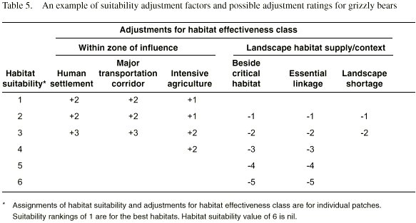
Grizzly bears across BC often use groups or complexes of patches that meet several life requisites. The location, size, configuration, overall landscape supply, availability of seasonal alternatives, degree of human disturbance and connectivity of any polygon or patch ultimately determine grizzly bear habitat value. For example, a forested patch adjacent to a salmon spawning stream may be very important for bears to rest in and avoid other bears that are actively catching fish. That same forested type growing among rock outcrops may have no value to bears. Adequate habitat evaluation must therefore put patches in their landscape context. Habitat effectiveness classes are adjustments of generically assigned habitat suitability ratings for each patch that reflect patch and landscape characteristics. Table 5 is an example of suitability adjustment factors and possible adjustment ratings. Other suitability adjustment factors include patch fragmentation and isolation, size or seasonal supply of an important bear habitat type.
Ideally, foraging WHAs should be designated according to cumulative effects analysis. In the absence of a formal cumulative effects analysis, managers should try to consider the full range of potential impacts, their spatial distribution and relation to other developments in the landscape unit, and the timeframe of these effects. Where there is grizzly bear habitat and there are RMZ objectives to manage for grizzly, the goal is no net loss of habitat effectiveness over time. Therefore, where developments reduce the effectiveness of habitat within a landscape, foraging WHAs should be established. WHAs should be of similar size and effectiveness class as the developed habitats prior to alienation, alteration, fragmentation or loss. Alternatively, where restoration is an objective, foraging WHAs should be established to recover effectiveness lost to historic development.


